Google DeepMind Just Released a New Forest Map. Here's How It Stacks Up Against the EU's GFC2020 for EUDR.
A single global forest map cannot decide whether a smallholder coffee plot is compliant. In agroforestry country it over-maps forest and flags the wrong farmers, and the EU body that publishes the most-used map says as much itself.
On 30 December 2026, roughly six months from now, the EU Deforestation Regulation will take effect for large operators. Every shipment of coffee, cocoa, rubber, soy, palm, cattle, or wood entering the EU will need a Due Diligence Statement showing the commodity was not grown on land deforested after 31 December 2020. Proving it rests on two inputs, the coordinates of the plot and a map of what counted as forest at the cut-off. The coordinates are the data everyone is focusing on while the map remains overlooked. This is in part because the European Commission is giving one away for free, but that free map is a major problem.
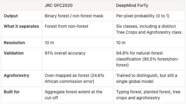
The Commission's Joint Research Centre publishes Global Forest Cover 2020 (GFC2020), a 10-metre map of where forest stood at the EUDR cut-off. It reports an overall accuracy of 91%. We can see its limitations with a simple comparison of layers over the Ugandan slopes of Mount Elgon, famous coffee country. GFC2020 on the left and Google DeepMind's natural-forest layer on the right. They significantly disagree across the same hillsides where roughly 90,000 smallholders grow Arabica. The verdict is glaring. Under GFC2020, half of Mount Elgon's coffee farmers are non-compliant despite data showing the majority should be.
A 91% accurate map can still be wrong exactly where it matters
Overall accuracy is an average across the whole planet. An average hides where the errors cluster. GFC2020's own accuracy assessment puts the global commission error for forest at 18%, meaning roughly one in five pixels labeled as forest is not. In Africa, that commission error climbs to 24.6%. The cause for this jump? The JRC states that GFC2020 cannot distinguish between forest and "agricultural tree plantations or agroforestry systems." The map is most wrong precisely in the landscapes where smallholder coffee, cocoa, and rubber actually grow.
In a compliance setting, that commission error behaves like a systematic bias, and it runs one direction. Independent work backs this up. Across 21 publicly available global forest maps assessed against EUDR criteria, only 2 met all the indicators, and the maps collectively claim about 12% more forest in 2020 than national data compiled by the FAO suggests. This clear exaggerated estimation of forest cover means they will over inflate non-compliance.
The map says forest. The farmer says coffee.
Shade-grown coffee is a productive form of agroforestry. The view from above sees only the canopy it creates, thus a global classifier trained to find "tree cover" labels these plots as forest. Melvin Lippe of Germany's Thünen Institute put it exactly: "the map says it's forest, but in reality it's an agroforestry system, which looks like a forest from on top." His team tested this on the ground. In a Mexican pilot program of 600 smallholder coffee plots between one and five hectares, many of them agroforestry systems decades older than the cut-off, the global maps incorrectly flagged 75% of them as non-compliant. A separate study in Indonesia found that an agroforestry garden growing coffee, cocoa, or rubber had roughly a two-thirds chance of being mis-mapped as forest.
Here is the part that should stop a compliance team cold: the EUDR's own text agrees with the farmer, not the map. Recital 37 of the regulation states that agroforestry systems are not forest; they are agricultural land use. The FAO forest definition these maps use explicitly excludes "land that is predominantly under agricultural or urban land use." So when a global layer paints a 40-year-old shade-coffee garden as forest, it contradicts the legal definition it claims to implement. Unfortunately, the consequence of this mislabeling lands on a real person. Mount Elgon's farmers work plots mostly under 2.5 hectares, around 70% of Uganda's coffee goes to Europe, and these lots are aggregated under large importers of record, not handled as SMEs, so the operator owes deforestation and legality checks on every plot whatever the country-risk class, even though Uganda is only standard-risk. A false "forest" pixel turns a compliant farmer into a flagged one, and a flagged smallholder is the easiest one to drop from the supply chain.
"Better map" is the wrong fix
Is switching from JRC to DeepMind's the right answer? Well, that would be too easy. The two products were built to do different jobs.